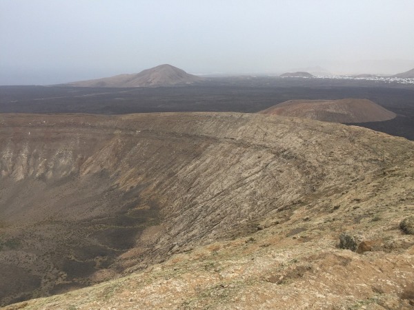
Caldera Blanca in Lanzarote, route up to the crater
Caldera Blanca is one of the most beautiful volcanic trails you can hike in Lanzarote. The trail crosses a field of black lava, passes by La Caldereta and climbs up to the rim of a huge, clear, open crater, offering one of those 360-degree views that perfectly explain why this island is so captivating.
For me, it’s one of the most special walks in Lanzarote. Not because it’s the easiest or the shortest, but because it captures the island’s character so well: lava, silence, wind, light and a volcanic landscape that seems to change with every step.
There are several ways to tackle the Caldera Blanca route. You can climb up to the rim of the crater and return the same way, or complete the circular route by walking around part of the caldera. Which route you choose depends on how much time you have, the wind, the heat and how keen you are to walk.
What is Caldera Blanca and why is it so well worth a visit?
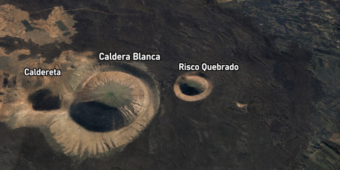
Caldera Blanca is a volcano located in the municipality of Tinajo, near Mancha Blanca and within the Los Volcanes Natural Park. It is one of the best-known hiking trails in this part of Lanzarote, as it allows you to walk amongst lava flows and climb up to one of the island’s most spectacular craters.
The best part isn’t just at the top. The journey is well worth it right from the start. First you cross a landscape of black lava, then La Caldereta comes into view, and, little by little, Caldera Blanca looms larger in the distance.
The contrast is stunning: dark lava all around and a light-coloured mountain standing out in the middle of the landscape. That mix of black, white, ochres and open sky is quintessentially Lanzarote. If you’re planning a few days on the island, Caldera Blanca fits in perfectly with other nature and coastal excursions. For example, you could spend one day exploring the volcanic landscape of Tinajo and another discovering Famara beach, where you can also try a few surfing lessons in Famara if you fancy experiencing Lanzarote from the water.
A volcano amidst black lava, silence and open countryside
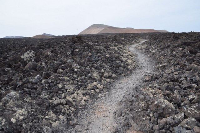
The first part of the route crosses a lava field. The terrain is uneven, dry and very exposed, with no shade and that distinctive, mineral-like feel so characteristic of this part of the island.
It’s a landscape that takes your breath away even before you start the climb. There are places where it feels as though you’re walking on another planet, yet you haven’t left Lanzarote. And for those of us who are from here, it still holds a special charm, no matter how many times we see it.
Why is it called Caldera Blanca?
The name comes from the mountain’s light colour. Set against the black of the volcanic flows that surround it, Caldera Blanca has a whitish or beige hue, caused by erosion and the natural weathering of the rock.
You don’t need to get too technical to understand it. What matters is that visual contrast: you walk over black lava and end up climbing up into a much lighter-coloured caldera, which is enormous and clearly visible from a distance.
La Caldereta, the first stop before the great crater
Before reaching Caldera Blanca , you’ll pass La Caldereta, a smaller crater that serves as the route’s first natural stopping point. Many people pass through this area almost without stopping, but it’s worth taking a moment to look around. It helps you understand the landscape and prepares you well for what comes next: the climb up to the great caldera.
Quick facts for the route
Useful information | Useful information |
|---|---|
Location | Tinajo, near Mancha Blanca |
Environment | Los Volcanes Nature Reserve |
Type of route | Volcanic trail |
Approximate distance | Around 10 km if you do the whole route |
Approximate duration | Between 3 and 4 hours, depending on your pace and the route |
Difficulty | Easy/moderate |
Best moment | Early tomorrow or a mild afternoon |
Essential | Water, sturdy footwear, sun cream and a windbreaker |
Ideal for | Hiking, volcanic landscapes and panoramic views |
Distance, duration and approximate elevation gain
The route doesn’t have a set duration, as it depends very much on how you approach it. If you climb to the rim of the crater and turn back, it will take less time. If you walk around the caldera, stop to take photos and take your time walking along the ridge, allow for more time
The entire route is around 10 kilometres long. It’s not an excessive distance if you’re used to walking, but the volcanic terrain makes it feel more challenging than a flat path.
As a rough guide, you can allow between 3 and 4 hours to do it at a leisurely pace. If you just want to climb up to the rim of the crater and back, you can cut the time down considerably.
The gradient isn’t steep, but you can really feel the climb. Especially towards the end, when the path becomes more uneven and you start to gain height towards the rim of the caldera.
Actual difficulty of the route
Caldera Blanca isn’t a technical route, but I wouldn’t describe it as an easy walk for everyone either. The real difficulty depends on three things: the heat, the wind and your footwear. I always recommend wearing good shoes. There are sections of loose stone and uneven ground, especially on the climb up to the crater. You can do it in trainers without proper grip, but it’s not ideal.
If you’re used to walking, you’ll find this a manageable route. If you don’t go hiking often, take it easy and don’t feel obliged to complete the whole loop.
Short route or full route: which option to choose
This is one of the most common questions. Do you have to go all the way round the boiler for it to be worth it? In my view, not necessarily.
If you’re short on time, if it’s windy, or if you don’t fancy a long walk, you can climb up to the rim of the crater, enjoy the views and head back the same way. It’s still a lovely experience.
If you enjoy walking and the weather is on your side, the full route is well worth the effort. Walking around the caldera allows you to see it from different angles and really appreciate the volcanic landscape that surrounds it.
Option | Who I would recommend it to | Approximate time |
|---|---|---|
A short walk to the edge of the crater | If you’re short on time, travelling with children, or the wind is a bit of a nuisance | Around 2–2.5 hours, depending on your pace |
Full or circular route | If you enjoy walking and want to take your time admiring the view | About 3–4 hours |
Only the first section through the badlands | If you’re looking for an easy introduction to the volcanic landscape | It varies depending on how far you get |
How to get to Caldera Blanca and where to park
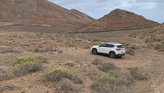
To get to Caldera Blanca, the main landmark is Mancha Blanca, in the municipality of Tinajo. From this area, you can reach the start of the trail via a dirt track that leads to the usual car park for the route.
You can use GPS, but it’s a good idea to check your destination carefully before setting off. In Lanzarote, some sat-navs insist on taking you down rough tracks, so it’s best to have a clear reference point: Mancha Blanca, the LZ-67 road and the Caldera Blanca car park.
Coming from Mancha Blanca via the LZ-67 road
The most common way is to drive to Mancha Blanca and take the access road to the trail from the LZ-67. Don’t expect a visitor centre with extensive facilities or tourist services. It is a hiking trail set in a natural volcanic landscape.
The LZ-67 road is a very useful route as it connects this part of the island with the area around Timanfaya National Park and Los Volcanes Natural Park.
Caldera Blanca car park
There is a free car park near the start of the trail. To get there, you’ll need to drive along a short dirt track. You can usually manage it in a standard car, but it’s best to drive slowly and take your time.
If you find there are a lot of cars, please don’t park haphazardly or block the paths. This is a natural area, space is limited, and it’s best to keep the access routes clear.
Do you need a map or GPS to follow the route?
The route is signposted and the main path is usually quite clear. Even so, I recommend making sure your mobile phone is fully charged and, if possible, having an offline map or the route saved on your device.
It’s not a route where you’re likely to get lost if you stick to the path, but in an open volcanic landscape, with stony tracks and few urban landmarks, it’s always a good idea to be prepared.
The Caldera Blanca Route: Step by Step
The route can be divided into four sections: the path across the lava field, the section through La Caldereta, the climb to the crater rim, and the return journey, which can be done via the same route or by completing the circular walk.
The great thing about this hike is that it gets better and better as you go. You start off walking through the barren landscape, and little by little the view opens up until you reach the top, where the real reward awaits.
First section across the lava field
The start of the route crosses a field of black lava. The path winds its way through volcanic rocks, uneven terrain and a wide-open landscape.
This part alone is well worth the trip. It’s Lanzarote at its best: lava, silence, dark hues and that feeling of walking across terrain that looks as though it’s fresh from an eruption, even though the landscape has a much longer history behind it.
A visit to La Caldereta
La Caldereta comes into view before you reach Caldera Blanca. It’s smaller, but it helps you get a feel for the route and makes for an interesting first stop. You can pause for a moment, take in the crater, and then carry on towards the main destination of the route. It’s a good way to ease yourself into the landscape.
Climb to the rim of the crater
The climb up to the edge of Caldera Blanca is the section where you really feel the strain. It isn’t particularly long, but the ground is loose with loose stones, so you need to tread carefully.
This is where it really pays to wear shoes with good grip. There’s no need to rush or push yourself. It’s better to take it slowly, watch your step and save your energy so you can enjoy the view at the top.
When you reach the rim of the crater, the view suddenly opens up. The caldera is much larger than it appears from below, and that first glimpse is usually the highlight of the walk.
A ridge walk and circular route
If you decide to do the full route, you can continue along the ridge and go round the caldera. This section is spectacular, but it’s also advisable to proceed with caution.
It’s usually windy up there. Sometimes just a bit, sometimes quite a lot. There’s no need to panic, but you should use your common sense: don’t get too close to the edge and avoid taking risks just to get a photo.
The circular walk allows you to view the crater from different angles and enjoy a wider view of the volcanic landscape.
Descent and return to the car park
The descent may seem straightforward, but it’s easy to get overconfident. The loose stones mean it’s best to take it slowly.
Once you’re back on the main path, the walk back to the car park takes you through the same lava landscape you saw at the start. It’s a good time to look back and see the silhouette of Caldera Blanca from a different angle.
What can be seen from the summit of Caldera Blanca
The best part of the route comes when you reach the top. From up there, you’re treated to a stunning 360-degree view: the crater at your feet, the sea of lava all around, and, on a clear day, much of Lanzarote’s volcanic landscape.
It’s a view that photos just can’t do justice to. You can take plenty of them, of course, but until you’re up there yourself, you don’t really grasp the size of the crater or the vastness of the landscape.
The Caldera Blanca crater
The crater is impressive in size. From the rim, you can really appreciate its scale and the contrast between the light-coloured interior of the caldera and the dark lava flows surrounding it.
If you’re into photography, this is one of the most photogenic spots along the route. The light, the shadows and the colours of the landscape really help.
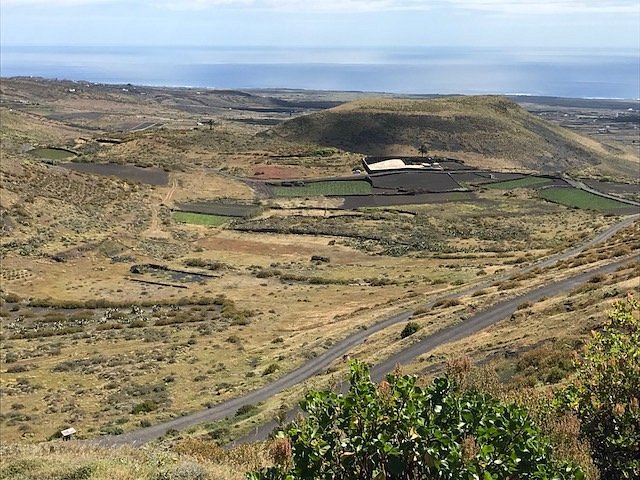
Views of Timanfaya and Los Volcanes Natural Park
From the higher ground, you can clearly see how this route ties in with Lanzarote’s volcanic landscape. Timanfaya and the Los Volcanes Natural Park form part of the backdrop.
Caldera Blanca isn’t like Timanfaya. You don’t take a coach here, nor do you follow a set route. Here, you walk, you climb, and you earn the view step by step. That’s part of its charm.
360-degree panoramic view of Lanzarote
The 360-degree view is one of the main reasons to take this route. On clear days, the sense of space is immense.
My advice is not to just go up to take a photo and then rush back down. Stay for a while, look at the crater, take in the lava field, and let the landscape work its magic.
Tips before setting off on the Caldera Blanca route
The Caldera Blanca route is a rewarding one, but you do need to prepare a little. You don’t need to be kitted out as if you were crossing half a mountain range, but it’s a good idea to take the essentials.
Quick checklist before you leave
What to bring | Why it is important |
|---|---|
Footwear with good grip | There are loose stones and uneven ground |
Enough water | There is no shade or water sources along the route |
Sun protection | The sun is still strong, even on windy days |
Cap or hat | Particularly useful during the brightest hours of the day |
Lightweight windbreaker | It can get quite windy on the ridge |
Mobile phone with a battery | For GPS, photos and security |
Something to eat | Highly recommended if you’re doing the full route |
Common sense | Especially on the climb, the ridge and the descent |
What shoes to wear
Ideally, you should wear lightweight hiking boots or mountain trainers with good soles. The volcanic terrain features loose stones, lava and uneven sections. I’d avoid sandals, flip-flops or trainers with very smooth soles. You see all sorts of things on the trails in Lanzarote, but that doesn’t mean everything is a good idea.
Water, sun and sun cream
If you’re going on a hot day, take more water than you think you’ll need. There’s no shade in this area, and although the route may seem straightforward on paper, the sun and wind can make it more challenging.
I’d also recommend a hat, sun cream and sunglasses. The volcanic terrain reflects a lot of light, and it can get quite intense during the middle of the day.
Watch out for the wind at the summit
It’s usually quite windy up there. There’s no need to panic, but you should do take care when walking, especially if you’re heading along the ridge.
If the wind is a bit of a nuisance, it’s no big deal if you don’t complete the full circuit. Just walking up to the edge, taking in the view and heading back is a fantastic experience in itself.
Stay on the path
This is an important point. In a volcanic environment like this, straying from the path can damage a landscape that takes a very long time to recover. Furthermore, walking on uneven lava outside the path can be dangerous.
The route is marked for a reason. Enjoying Caldera Blanca also means respecting it.
Is Caldera Blanca suitable for children?
Caldera Blanca is suitable for children, but there are a few caveats. I wouldn’t describe it as an easy family walk under all circumstances, as it depends very much on the children’s age, the heat, the wind and how used to walking they are.
If you’re going with children, I’d suggest using your common sense. The first section is easy going and visually very beautiful, but the climb and the upper section require more care due to the stones, the wind and fatigue.
Which section is the easiest?
The initial section across the lava field and through the La Caldereta area is perhaps the easiest part of the walk. It allows you to enjoy the volcanic landscape without having to complete the entire route. If you’re travelling with young children, it might be a good idea to do a shorter version: walk as far as the group feels comfortable, stop, enjoy the scenery, and head back without any pressure.
When it is best to avoid the full climb
I’d avoid doing the full climb with children if it’s very hot, if the wind is strong, or if they aren’t wearing suitable footwear. The route isn’t about proving anything. If the weather isn’t on your side, it’s better to do a shorter version and make the most of it.
The geology of Caldera Blanca explained in simple terms
Part of Caldera Blanca’s charm lies in its geology. You don’t need to be an expert to appreciate it, but understanding the landscape a little helps you see it in a new light. In this area, older volcanoes stand alongside more recent lava flows. That’s why you see a light-coloured mountain surrounded by a sea of black lava.
The contrast between the black lava and the light-coloured volcano
Caldera Blanca stands out because its light colour breaks up the dark landscape around it. As you walk towards it, that contrast becomes increasingly apparent.
The black lava comes from volcanic flows that covered part of the terrain. The caldera, which is lighter in colour and eroded, stands out like an island within this dark landscape.
What are malpais, lava flows and volcanic islets?
In Lanzarote , we call the areas of uneven, rough lava that are difficult to traverse off the beaten track ‘malpaís’. It is not easy terrain, but rather harsh volcanic ground, with jagged shapes and sharp rocks.
Lava flows are the rivers of lava that spread out during eruptions. Volcanic islets, meanwhile, are areas of older terrain that have been surrounded by more recent lava.
Connection with Timanfaya and the Los Volcanes Natural Park
This whole area bears clear traces of Lanzarote’s volcanic history. Its proximity to Timanfaya and the Los Volcanes Natural Park helps to explain why the landscape is so different from that of other parts of the island.
Caldera Blanca allows you to experience that contrast on foot, without any barriers and at your own pace. That’s one of the reasons why I think it’s such a highly recommended route.
Frequently asked questions you might have
About the author

Maike Famara
Director of Surf Famara. A free surfer from the 1970s, renowned in the Canary Islands, he has surfed on five continents (the entire South African coast, Western Australia, Indonesia, Peru, Chile, Puerto Rico, Panama, France, Portugal, Senegal, Morocco...) and has dedicated himself to teaching and developing new surfers since 1996! You can find him in San Juan or La Santa, where he remains connected to the ocean like the first day.