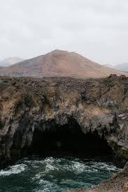
Los Hervideros de Lanzarote visits volcanic cliffs
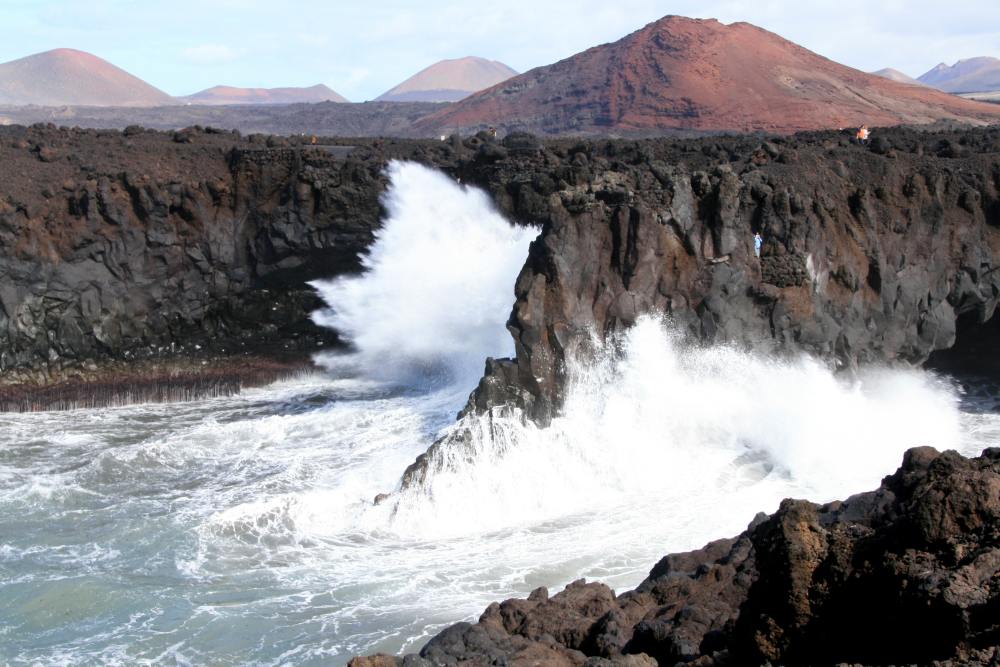
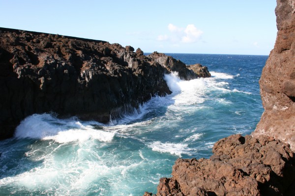
Los Hervideros is a stretch of volcanic coastline in Yaiza (Lanzarote), where ancient basaltic lava flows – linked to the Timanfaya National Park environment (eruptions 1730-1736) – formed cliffs, sea caves and bays. When the Atlantic swell presses in through the cracks, the water bursts into foam and gives the sensation of “boiling”.
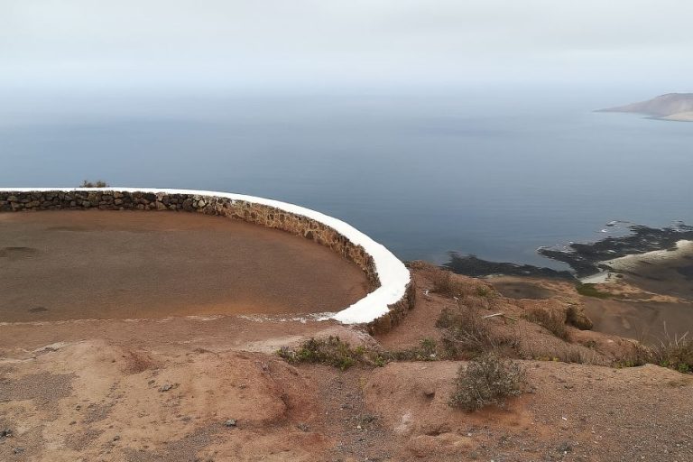
It is a natural and free place, with a path over lava and viewpoints. It is not a beach but a set of cliffs: it is advisable to wear stable footwear and to have a lookout mentality, not a bathing mentality. In essence, the “boil” appears when waves, lava caves and bufaderos (holes in the rock through which the sea blowswater and air under pressure) combine.
Where they are and how to get there
The enclave is located between the Salinas de Janubio and El Golfo, connected by the LZ-703 (coastal road). It is easily reached from the LZ-2 (southern axis) and the LZ-67 (Timanfaya). The final section of the route runs through a lava badlands with open views of the Atlantic. If you don’t have a car, consider renting a car in Lanzarote (insurance included) to move freely around Janubio, Hervideros and El Golfo.
Directions from Playa Blanca
Drive along the LZ-2 towards Yaiza and take the LZ-703 towards “El Golfo/Los Hervideros”. Short and scenic drive.
Directions from Arrecife / airport
Follow the LZ-2 south to Yaiza and turn off onto the LZ-703 towards “El Golfo/Los Hervideros”.
Map and coordinates
Searching for “Los Hervideros Yaiza” in your map app will take you straight there. The car park is next to the start of the route. The visit is usually short but intense (20-40 min) if you stop at viewpoints and caves to take pictures.
Price, timetable and duration of the visit
Los Hervideros is a 24/7 open space. There are no turnstiles or access control, so it’s totally free. The standard visit is around 30 minutes, but you can adjust:
Is there a timetable? How much time to devote?
- Express stop (15-20 min): 2-3 viewpoints and quick photos.
- Complete visit (30-45 min): a leisurely tour of the balconies, waiting for a series of waves and looking for frames.
- Sunset photography (45-60 min): extra margin for golden light and swell bursts.
Crowds tip: there are usually fewer people in the early hours of the morning and after sunset (when many people return to their accommodation).
Entrance and parking
- Price: 0 € (free).
- Car park: free esplanade next to the start of the trail. On days when the sea is very active or at peak times (afternoon and evening), it can fill up occasionally; just wait for a change (turnover is high due to the short duration of the visit).
- Access: The LZ-703 is the direct route (coastal section). Drive with caution: it is a scenic road and there may be gusts of wind.
Best time of day and conditions
- Boiling’ effect: triggered by medium-high tide combined with swell (swell).
- Light: sunset enhances the contrast between the black lava and the blue of the Atlantic.
- Weather and safety: in strong wind or extreme swell, take extreme caution and follow signage on walkways and railings.
Best time to visit the hotbeds of Yaiza
It is when the sea is rough that it really “boils”: the high tide and the sea at the bottom of the sea activate the bufaderos and raise the foam. On very calm days the scenery is still extraordinary, but the effect will be more discreet.
How to consult tides/waves
Before heading out, check tides and swell for the southwest coast of Lanzarote. Rule of thumb: medium-high tide combined with moderate/high swell offers the best show.
Trade wind: what to expect
The trade winds cool and can raise salt spray: wear a windbreaker and protect your camera equipment. The sunset light enhances the black-blue contrast of the lava and the sea; it is one of the best moments for photography.
Accessibility, accessibility and safety at the lookout points
The route is a signposted walk over lava with handrails and natural balconies. The cinder stone pavement and some of the steps call for soled footwear and attention to where you step.
Path over lava, handrails and picón pavement
Always stay on the designated trails: do not climb over rocks or cross barriers, both for safety and for the conservation of the badlands.
Going with children: safer zones
On rough sea days, it is advisable to take care and choose viewpoints with railings; a rhythm of short stops with explanations about the waves works well.
Is it possible to swim or go down to the rocks?
This is not a bathing area. There are cliffs, unpredictable waves and slippery surfaces; the aim here is to observe. Be especially careful of wind and wet rock, and avoid turning your back to the sea when taking photos.
Services and quick tips (what’s in and what’s not)
There are no toilets, bars or shade: it’s pure nature. Take water, a windbreaker and suitable footwear; for services, head to El Golfo or the Janubio viewpoints.
What to see nearby: triangle Janubio – Hervideros – Charco de los Clicos
A very efficient way of visiting the island is the triangle Janubio → Hervideros → El Golfo: starting with the Mirador de las Salinas de Janubio (photogenic geometries), continuing with the Los Hervideros snorkelling spots and finishing at the Charco Verde or Charco de los Clicos (green marine lagoon due to phytoplankton) before eating fish in El Golfo.
- Salinas de Janubio (viewpoint and photos): Active salt landscape; at sunset the salt pans gain volume and contrast.
- Charco Verde (Lago de los Clicos): Marine lagoon with an intense green tone due to microfauna; it contrasts with the black sand of the surroundings.
- El Golfo (where to eat fish): Seafaring village with restaurants by the sea; excellent for closing the route.
- Mirador del Río: A day with architecture by Manrique and views of La Graciosa.
With an extra day, you can visit Famara to explore the north of Lanzarote between cliffs like the mirador Risco de Famara, you can also learn to surf in the numerous surf schools. If you’re looking for natural pools in Playa Blanca, check out Los Charcones (only at low tide and calm seas).
Distances and times (approximate by car)
The table is based on normal traffic conditions. Times are rounded.
| Origin | Approx. km | Approx. time |
|---|---|---|
| Playa Blanca | 16-18 km | 20-25 min |
| The Gulf | 3-5 km | 5-10 min |
| Puerto del Carmen | 28-32 km | 35-40 min |
| Arrecife / Airport (ACE) | 32-36 km | 40-45 min |
| Caleta de Famara | 42-48 km | 55-60 min |
Sustainability and standards when visiting the hotbeds of Lanzarote
Los Hervideros is a combination of the strength of the Atlantic and the recent geology of Lanzarote. A visit is a must and combines perfectly with Janubio and Charco Verde on the same outing. When you go, respect the environment.
- Do not leave litter (including cigarette butts) or feed wildlife.
- Don’t pick up stones or build “towers”.
- Don’t leave the path; protect the badlands and your safety.
- Keep noise down and respect the quietness of the environment.
- Drones: check local regulations; wind is often a limiting factor.
Some frequently asked questions you may have if you go to the hotbeds
About the author

Maike Famara
Director of Surf Famara. A free surfer from the 1970s, renowned in the Canary Islands, he has surfed on five continents (the entire South African coast, Western Australia, Indonesia, Peru, Chile, Puerto Rico, Panama, France, Portugal, Senegal, Morocco...) and has dedicated himself to teaching and developing new surfers since 1996! You can find him in San Juan or La Santa, where he remains connected to the ocean like the first day.